
| Date: | 28/07/2014 |
| Start time: | 10:30 |
| Time taken: | 2 Hours |
| Distance: | 4 miles |
| Weather: | Warm and sunny |
| Route: | Eyemouth – Coldingham Bay – St Abbs |
For this a trip I planned a foray out of England, into Scotland for a walk along the coastline north of Eyemouth. I’ve previously walked up the coast from the border so this walk was conceived to continue my coastal exploration further north. The warm, clear day with plentiful blue sky was an added bonus.
The walk starts in the coastal town of Eyemouth. With it being the middle of summer, and the weather being dry and hot there were plenty of tourists out and about making the most of the weather. The first challenge for me was to find the start of the footpath which follows the coastline north out of the town.

After a bit of searching I discovered the path leaves from the beach, via a set of steps that climb up the cliff. Once at the top of the cliff the path follows the headland between the top of the cliff and the static caravans of a large holiday park rowed up facing the sea. At the top of the steps turning around gives a good overview of Eyemouth with the beach in the foreground and the town’s buildings behind.


Rounding the corner at the northern end of the headland a wide view up the coast reveals itself. The settlements at Coldingham Bay and St Abbs are easy to spot huddled at the top of their respective bays. Behind a multicoloured patchwork of arable fields climb away from the coast in the form of soft and rounded hills.
This was the first site I’d had of my destination and the type of terrain I would be walking through for the next couple of hours. From here the path either traverses the land between the arable fields and the cliff top or drops down to the beach and crosses the beaches at the cliff foot.


The path along the edge of the field was narrow but obviously well used. The grass either side of the path was long, and this was perhaps not the best thing for a sufferer of hayfever such as me.

At Brennison’s Brae the path turns a corner and a takes a route inland overlooking the mouth of Fleur’s Dean. The low tide at this point meant that the rocky shore line beyond the beach was exposed which perhaps lessened the drama, but did increase the interest of the wave cut rock shelves.

Still following the Berwickshire Coast Path the route I took cut back inland and down into Fleur’s Dean itself. The steep sided ravine has a grassy bottom and the shape of the terrain partially hid the sea from view until I got closer to the beach again when the sea reappeared.

After exiting Fleur’s Dean the path heads north along the beach at Limkin Shore for a short stretch. On the beach I noticed a strange bronze sculpture in the sand (see pic above). It turned out that the post was one of twelve markers along the route which link together the communities affected by the 1881 East Coast Fishing Disaster. A leaflet available on The Scottish Borders Council website gives an insight into the Berwickshire Coastal Path and it associated trail markers, of which I’d only spotted one on this walk.

After reascending the cliff at the north end of Linkim Shore the path finds itself beside more arable land. As I passed a combine happened to be working its way slowly around the outside of the field harvesting the oilseed rape crop. It was fairly dusty so I kept well back!

After traversing the cliff top Yellow Craig Head is rounded and a view down into a small bay at the mouth of the Milldown Burn is revealed. The bay is one of several on this stretch of coast, except this one has a stony beach rather than a sandy one. Until recently the Milldown Burn was crossed via a set of stepping stones, however a new footbridge has been built. This increases the safety and likelihood of staying dry, but is dramatically less “fun” than crossing stepping stones and risking a dip in the burn.

Climbing up to the top of Homeli Knoll, a rounded mound on Mildown Point, an unexpected site revealed itself: a beach with tourists. After walking up the coast I didn’t expect to see a sandy beach with beach huts, lifeguards, bathers, a cafe, toilets, and homes overlooking the bay, but I did. Coldingham Sands appeared to be quite popular with bathers, no doubt helped by the nice weather and its proximity to St Abbs and Coldingham.


The path descends to the edge of Coldingham Sands and crosses the head of the beach in front of the cafe, lifeguard station and plentiful multicoloured beach huts. At the north end of Coldingham Sands the path climbs the cliff again for a final cliff top section before reaching St Abbs. Here I found the path became slightly vague, especially around the grounds of the modern glass and metal house which can be seen in the photos above.
As it was low tide the bathers at Coldingham Sands were having to walk quite a distance from their blankets, shelters and picnics high up the beach to get to the waters edge to plodge and swim in the sea.
From the cliff top an expansive view back down the coast towards Eyemouth reveals itself. The rocky shoreline creates an interesting scene which displays most of the coastline traversed on this walk.

After a short final section of open coast St Abbs is reached.
Having never been here before I decided to explore the small village and sea what it had to offer. It only has a few streets away from the harbour, the ones closest the sea being traditional terraces of single storey fisherman’s houses.
The village has a small post office and shop, a small museum and tourist information office and a similarly small community centre. Village activity is centred around the harbour.

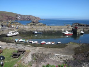
Looking down on the harbour a variety of small water craft were tied up in the little harbour. They mainly appear to be small pleasure boats and craft belonging to diving trip operators.


In common with the other fishing communities on this stretch of coast St Abbs lost a number of fishermen in the East Coast Fishing Disaster of 1881 in which an unexpectedly large storm led to 189 fishermen losing their lives. The figures on top of the monument (pictured above) depict the wives and children of the fishermen who lost their lives peering out to sea looking to see if their husbands will return.

All in all this walk from Eyemouth to St Abbs was an enjoyable and untaxing walk along the coast. As the sea is always close by on the eastern side and the path is well used navigation is easy. I discovered a few empty bays and beaches and the busier Coldingham Sands which, though actually close to St Abbs, won’t be seen unless you go and look for it.
Done this walk today 25/7/15 fabulous walk great scenery picture post card harbour St St Abbs lovely small beach at Cold Ingham littlectreasure that I shall return to with my grand children
We did this walk today,25/10/16,very hard walk as all the paths were extremely muddy and we didnt realise there were so many steps to walk up and down but still a very beautiful and scenic walk,will definitely do it again when the paths are dried up.The description on this site is really good as it tells you about the entire walk,well done.
done this walk in the 1970’s when i was a child still doing it today 2018